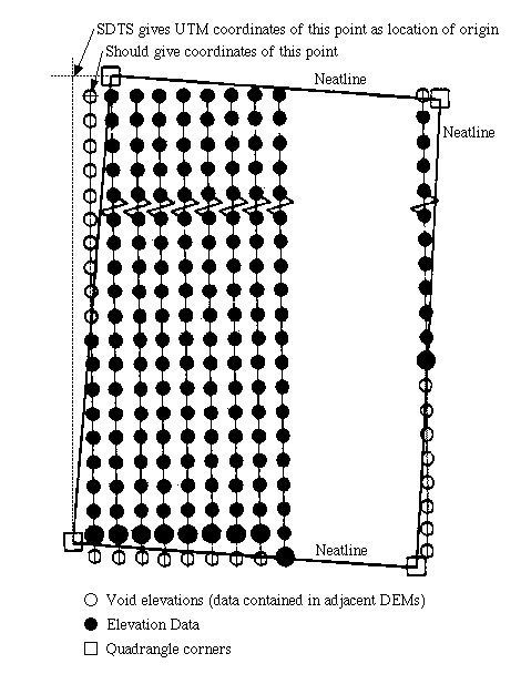
Old SDTS-formatted DEM files have an error in their geopositioning data. The SDTS format has data fields which are supposed to specify the location of the origin (northwest corner) of the rectangular array of elevation data. These fields actually contain the northernmost and westernmost extent of the quadrangle corners. Thus, any program that positions the DEM based on the origin data will end up positioning the data incorrectly. The nature of the error is such that the error should always be less than one grid cell (typically 30 meters). However, when tiling adjacent DEMs together this error can create a gap between the DEMs. MacDEM uses other data in an attempt to correctly position old SDTS data to avoid these gaps.
SDTS files created after Jan 1, 2001 reportedly do not have this error.
I believe the data available at GIS Data Depot does not have the error.
The USGS has posted some information on this page:
USGS
SDTS DEM Positional Error
If you have additional information or corrections to this page, you can contact me at macdemweb@treeswallow.com
- Jerry Farm
This figure is based on Figure 1-1, "Structure of a 7.5-minute digital elevation model, UTM meter grid," of Standards for Digital Elevation Models, Part 1: General, from the U.S. Geological Survey, National Mapping Division.
| http://www.treeswallow.com/macdem |
Created: 2000.03.08 |